Volcano Watch Screensaver
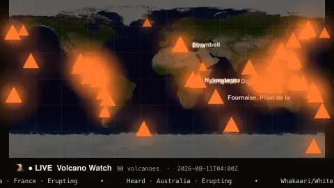
The Volcano Watch screensaver is a world map of currently erupting and restless volcanoes, pulsing at their locations with name, elevation and activity, from the Smithsonian Global Volcanism Program via Afterglow's pipeline. It's free, runs in your browser, and ESC exits.
Live preview
Press ESC to leave fullscreen. Settings are saved in your browser only.
How the Volcano Watch screensaver works
A background pipeline pulls the Smithsonian Global Volcanism Program's volcano list and keeps those active in recent years, saving a small snapshot file.
The saver plots each volcano on a world map as a pulsing triangle with a warm heat glow, larger for the most active.
Notable volcanoes are labelled, and a ticker reads off names, countries and activity status.
The snapshot refreshes periodically so the map reflects current activity.
The Smithsonian's Global Volcanism Program
The Global Volcanism Program is part of the Smithsonian Institution’s National Museum of Natural History. Its Volcanoes of the World database describes volcanoes that have been active during the Holocene, the current geological epoch since the end of the last ice age, along with their eruptions. The volcano list is a reference database, not a live seismic monitoring network.
Each volcano record includes its location, elevation, country and volcano type, and the date of its most recent known eruption where one exists. The status shown on a map such as this reflects the program’s classification and the dates it records, so it describes how recently a volcano has been active. It is not a minute-by-minute alert, and a volcano marked as erupting may be producing only small or intermittent activity.
Volcanoes behave in very different ways: some erupt almost continuously at a low level, others rest for centuries and then wake with little warning. Official alert levels come from the monitoring agencies responsible for each volcano, such as national geological surveys and volcano observatories. For safety information near a volcano, those agencies are the authoritative source, not a general overview map.
A worked example
Heat-glowing markers pulse along the Ring of Fire and beyond — Etna · Italy · Erupting, Kilauea · USA, Stromboli — the ticker naming each one while the brightest mark the volcanoes most recently active.
Settings & tips
- Glow color sets the heat color of the markers.
- Background sets the map backdrop.
- Run
automation/run.py volcanoon your pipeline machine to refresh the snapshot.
Frequently asked questions
- Is this real volcano data?
- Yes. It's from the Smithsonian Global Volcanism Program, filtered to volcanoes active in recent years, refreshed on a schedule.
- Does “erupting” mean right this second?
- It means activity in the current period per the Smithsonian record; the map highlights recently and currently active volcanoes, not a live eruption camera.
- Why does it use a pipeline?
- The Smithsonian feed isn't readable directly from a browser, so a small background script fetches it and saves a snapshot the saver loads.
- Does it need a key?
- No keys anywhere — the source is free and the saver just reads the saved snapshot.
- Is it free?
- Yes — free, no download, in your browser.
- What does Holocene mean in a volcano catalogue?
- It is the current geological epoch, which began at the end of the last ice age. A volcano that has erupted in that period is considered potentially active and is included in the catalogue.
- Where do official volcano warnings come from?
- From national or regional volcano observatories and geological surveys, which monitor their own volcanoes and issue alert levels for them.
- Does a larger or taller volcano mean more dangerous?
- Not necessarily. Hazard depends on eruption style, nearby population and local terrain, not on height alone.