Military Aircraft Spotter Screensaver
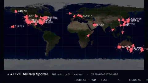
The Spotter screensaver is a live world map of military and special aircraft in the air right now — callsign, type and altitude — sourced from the open ADS-B community network through Afterglow's background pipeline. It's free, runs in your browser, and ESC exits.
Live preview
Press ESC to leave fullscreen. Settings are saved in your browser only.
How the Spotter screensaver works
A background pipeline pulls military and special aircraft from the adsb.lol community ADS-B network, which is key-less but can't be read directly by a browser, and saves a small snapshot file.
The saver loads that snapshot and plots each aircraft on a world map as a small triangle pointed along its heading.
Aircraft carry a short motion trail and are labelled with their callsign; a live count and ticker list types and flight levels.
The snapshot refreshes on a schedule so positions stay current.
Reading ADS-B tracks of military and special aircraft
ADS-B, short for Automatic Dependent Surveillance-Broadcast, is a system in which an aircraft broadcasts its identity, position, altitude and velocity from its transponder, on a radio frequency that anyone can receive with inexpensive equipment. Enthusiasts around the world run receivers and share the data. adsb.lol is a community-fed aggregator that publishes an open API and open data from its feeders.
The map relies on volunteer coverage, so it is strongest where receivers are dense and thin over oceans and remote regions. Aircraft only show up if their transponders are broadcasting; some military flights switch ADS-B off or limit what they share, so the picture is incomplete by design. Military flags depend on registry lists and codes and are imperfect.
Callsigns are the identifiers used on a flight and can be generic or change from mission to mission. They do not necessarily reveal the operator or purpose. Altitude is shown as flight level, which is pressure altitude in hundreds of feet on a standard 1013.25 hPa setting, so it is a common reference rather than height above ground. The snapshot is a moment in time and movement continues after it was captured.
A worked example
Triangles crawl across the map — a C17 over the Pacific, a HAWK trainer over Texas — each tagged with its callsign and flight level, with the ticker reading off types as new aircraft appear and others land.
Settings & tips
- Aircraft color sets the marker and trail color.
- Background sets the map backdrop.
- Run
automation/run.py milairon your pipeline machine to refresh the snapshot.
Frequently asked questions
- Is the aircraft data real?
- Yes. It comes from the adsb.lol community ADS-B network — real transponder positions of military and special aircraft, refreshed on a schedule.
- Why does it use a pipeline?
- The ADS-B source is key-less but isn't readable directly from a browser, so a small background script fetches it and saves a snapshot the saver can load.
- Does it track every plane?
- No — it focuses on military and special aircraft. The Flight Radar saver covers civilian traffic around airports.
- Does it need a key?
- No keys anywhere. The pipeline uses a free community feed; the saver just reads the saved snapshot.
- Is it free?
- Yes — free, no download, in your browser.
- What does a flight level mean?
- Flight level is altitude in hundreds of feet measured against the standard pressure setting of 1013.25 hPa, so FL300 is nominally 30,000 feet. It is used above the transition altitude so that all aircraft share a common reference.
- Why do some military aircraft never appear?
- Some military flights limit or switch off their ADS-B transmissions, and others may be out of range of any volunteer receiver, so absence from the map says little about whether an aircraft is airborne.