Endangered Languages Map Screensaver
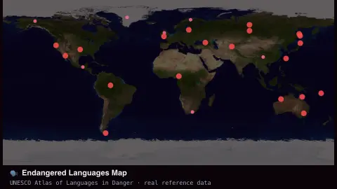
The Endangered Languages Map screensaver plots languages classified as endangered by UNESCO's Atlas of the World's Languages in Danger, a real dataset of linguistic diversity at risk. It's free, runs in your browser, and ESC exits.
Live preview
Press ESC to leave fullscreen. Settings are saved in your browser only.
How the Endangered Languages Map screensaver works
The map is shaded using UNESCO's real published Atlas of the World's Languages in Danger.
Each point represents a real language with its vitality level — vulnerable through critically endangered.
Filter to critically endangered languages only, or see the full real dataset.
Points slowly pulse to keep the display alive without implying live change.
UNESCO's atlas of languages in danger
UNESCO’s Atlas of the World’s Languages in Danger grew out of an effort in the 1990s to document threatened languages, and an online edition launched in 2009 alongside the third print edition of 2010. It compiles information about languages at risk of falling out of use, grading how vulnerable each is and recording where it is spoken and roughly how many speakers it has.
Vitality is graded on a scale, which the display uses to colour or filter the points. The levels run from vulnerable, where children speak the language but perhaps only at home, through definitely endangered, where children no longer learn it, and severely endangered, where only older generations speak it, to critically endangered, where the youngest speakers are grandparents or older. Extinct languages are recorded as well, but the map concentrates on those still spoken. The grading rests mainly on intergenerational transmission, the first of nine factors in UNESCO’s 2003 vitality framework, alongside speaker numbers, domains of use and available documentation.
The data have limits. Speaker numbers are estimates and often old, because many of these languages have never been counted carefully. A point marks an approximate location, while the language may be spoken across a wide or scattered area. A language can also have several dialects and names, so entries may overlap or be split differently in other catalogues. The map is a snapshot of the atlas, not live monitoring.
A worked example
Zoom your attention to the Pacific Northwest or Siberia and you'll see real clusters of critically endangered indigenous languages — genuine UNESCO classifications, not illustrative dots.
Settings & tips
- Show narrows the map to critically endangered languages only.
- Accent recolours the map points.
- This is real, published reference data — language status changes slowly, not live.
Frequently asked questions
- How many languages are endangered?
- UNESCO's real published Atlas lists over 2,500 languages at some level of endangerment — around 40% of all living languages.
- Is a key needed?
- No — it's a static, real-reference-data visualization with no live fetch.
- Is this official?
- Yes — it uses UNESCO's own published classification data.
- Is it free?
- Yes — free, no download, in your browser.
- How does UNESCO decide a language is endangered?
- Mainly by intergenerational transmission, meaning whether children are still learning the language, together with other factors such as the number of speakers and how the language is used in daily life. There is no single numeric threshold.
- Are languages with few speakers always endangered?
- No. A small community that passes the language to its children can be stable, while a larger one that switches to another language can lose it within a generation.
- Can an endangered language be revived?
- Revitalisation efforts, such as immersion schooling and community recordings, have strengthened some languages, but success depends heavily on community support and resources.