Deforestation Watch Screensaver
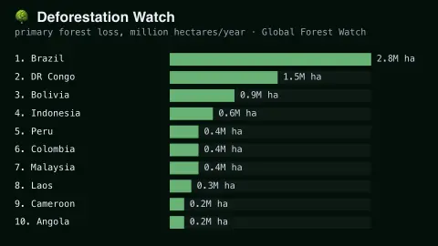
The Deforestation Watch screensaver ranks countries by real annual tree cover loss, from Global Forest Watch's own published satellite-derived data. It is free, runs in your browser, and ESC exits.
Live preview
Press ESC to leave fullscreen. Settings are saved in your browser only.
How the Deforestation Watch screensaver works
The saver displays real, published annual tree cover loss figures from Global Forest Watch's satellite monitoring program.
Countries are ranked by their real reported hectares of tree cover lost.
The board refreshes periodically as new real annual figures are published.
No live feed is required — figures are a real, curated periodic snapshot.
Reading tree cover loss from Landsat
Global Forest Watch is an online forest-monitoring platform run by the World Resources Institute. Its tree cover loss layer is based on the Global Forest Change dataset produced by researchers at the University of Maryland, led in the original 2013 Science paper by Matthew Hansen. It analyses Landsat satellite imagery at about 30-metre pixels, with tree cover defined as vegetation taller than five metres, and records the year in which loss is detected.
The key word is loss. The dataset detects removal of tree cover, not the reason for it. Clearing for farmland counts, but fires, storms, pests and rotational harvesting can also register as change, and tree cover includes planted forests and tree crops. Countries with large forestry industries or frequent fires can therefore show large numbers even where forest area is stable or recovering.
Countries differ in size and in how much forest they started with, so a ranking by raw hectares mostly favours large, heavily forested nations. The data are updated annually, with the newest year available only after analysis, and the methods have been updated over time, so documentation advises caution when comparing older and newer years.
A worked example
A country with real, extensive primary forest loss in a single year tops the board, exactly matching Global Forest Watch's own published figure.
Settings & tips
- Accent recolours the ranking bars.
- Figures are real satellite-derived measurements, not estimates.
- The board updates once each real annual reporting cycle.
Frequently asked questions
- Is this real satellite data?
- Yes — real, published annual figures from Global Forest Watch.
- Is a key needed?
- No — figures are a curated real periodic snapshot.
- Does tree cover loss mean deforestation?
- It includes real permanent deforestation as well as real natural loss like fire, per the source's methodology.
- Is it free?
- Yes — free, no download, in your browser.
- How big is a hectare?
- A hectare is 10,000 square metres, or about 2.47 acres.
- Does the data show forest regrowth?
- Not in the annual loss figures. The dataset’s separate tree cover gain layer covers only 2000–2012 and is not updated, so annual loss does not net off replanting or natural recovery.
- Why do the numbers differ from national forest statistics?
- Governments often use their own definitions of forest and field surveys, while this dataset uses one uniform satellite method that counts any loss of tree cover, so the two can disagree.