Norwegian Sea Forecast Screensaver
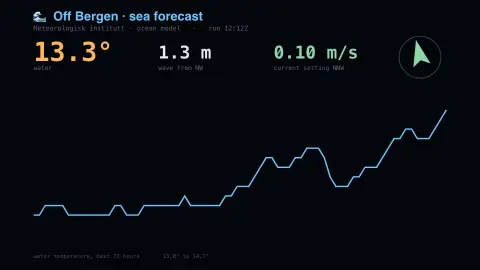
The Norwegian Sea Forecast screensaver shows the sea forecast for a point off the Norwegian coast from the Meteorological Institute, key-less: water temperature, wave height and the direction the current is running. It's free, runs in your browser, and ESC exits.
Live preview
Press ESC to leave fullscreen. Settings are saved in your browser only.
How the Norwegian Sea Forecast screensaver works
The saver reads the source described above and draws it on a canvas — no account, no tracking.
The sea forecast for a point off the Norwegian coast from the Meteorological Institute, key-less: water temperature, wave height and the direction the current is running. This is the ocean model rather than a swell model, so the current vector swings with the tide.
It refreshes on a schedule, so what you see stays current.
Colours and any options can be changed in settings; nothing is stored beyond your own browser.
About MET Norway's ocean forecasts
MET Norway, the Norwegian Meteorological Institute, publishes forecasts for the atmosphere and the sea. Its Oceanforecast service provides wave and sea forecasts for points at sea in northwestern Europe, based on multiple wave and sea models. Requests close to the coast are snapped to the nearest ocean point, so the point returned can differ slightly from the one asked for.
The values shown are for a single point off the coast, so they describe that patch of water and not the whole Norwegian Sea. Significant wave height is a standard measure of sea state: traditionally the mean height of the highest third of waves, so individual waves can be considerably taller than the number displayed. Current direction follows the oceanographic convention and gives where the water is moving towards, whereas wave direction in this service gives where waves come from.
This is forecast model output, not a buoy reading, and conditions inshore, among fjords and skerries, can differ a lot from open-water values. Warm water carried north along the Norwegian coast by Atlantic currents is widely credited with keeping the sea there milder than the latitude suggests.
A worked example
The sea forecast for a point off the Norwegian coast from the Meteorological Institute, key-less: water temperature, wave height and the direction the current is running. This is the ocean model rather than a swell model, so the current vector swings with the tide.
Settings & tips
- Accent and Background recolour the display.
- Every number on screen comes from the live source — nothing is simulated.
- Press ESC to leave fullscreen.
Frequently asked questions
- Is this real data?
- Yes — it comes from the source named on this page and is refreshed on a schedule.
- Is a key needed?
- No. This source is fully key-less.
- Is it free?
- Yes — free, no download, in your browser.
- What is significant wave height?
- A standard summary of sea state, traditionally defined as the mean height of the highest third of waves, so occasional individual waves exceed it.
- Is this a measurement or a prediction?
- It is model forecast output for a chosen point, not a direct reading from a buoy or vessel.
- Do wave and current directions mean the same thing?
- No. In MET Norway's Oceanforecast, wave direction is where waves come from, while current direction is where the water is going.