Ice Sheet Mass Balance Screensaver
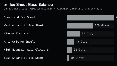
The Ice Sheet Mass Balance screensaver ranks major ice sheets by their real published annual mass loss, from satellite gravity research. It is free, runs in your browser, and ESC exits.
Live preview
Press ESC to leave fullscreen. Settings are saved in your browser only.
How the Ice Sheet Mass Balance screensaver works
The saver displays a real, curated ranking of major ice sheets and glaciated regions by their published annual mass loss.
Each region shows its real reported mass loss, in gigatonnes per year.
The board refreshes periodically as new real satellite research is published.
No live feed is required — figures are a real, curated periodic snapshot.
Weighing ice sheets with gravity satellites
A direct way to measure ice-sheet mass from orbit uses gravity. NASA and German partners flew a pair of satellites, GRACE (2002 to 2017), followed by GRACE Follow-On, launched in 2018. The twin satellites orbit about 220 km apart and send microwave signals to each other to track the distance between them. Gravity variations change that distance slightly, and mapping those changes month after month reveals where mass is being gained or lost.
Results are expressed in gigatonnes, a billion tonnes, per year. Individual regions, such as Greenland and Antarctica, are then compared with each other. Researchers often combine gravity data with altimetry and with mass-budget estimates from ice flow and modelled snowfall, as in the Ice sheet Mass Balance Inter-comparison Exercise (IMBIE), a joint ESA and NASA effort set up to reconcile estimates from different teams.
Caveats matter. The land under the ice is still slowly rising or sinking after the last ice age, a signal scientists must subtract with models, and that adds uncertainty. There was also an 11-month gap in the record between the two satellite missions. Numbers are multi-year averages or published estimates that get revised as methods improve.
A worked example
The Greenland ice sheet's real published annual mass loss appears exactly as measured by NASA and ESA satellite gravity missions.
Settings & tips
- Accent recolours the ranking bars.
- Figures are real satellite-derived measurements, not modeled estimates.
- The board updates as new real satellite research is published.
Frequently asked questions
- Is this real satellite data?
- Yes — real, published findings from NASA and ESA satellite gravity-measurement missions.
- Is a key needed?
- No — figures are a curated real periodic snapshot.
- How is ice mass measured from space?
- Satellites detect real tiny changes in Earth's gravity caused by shifting ice mass.
- Is it free?
- Yes — free, no download, in your browser.
- What is a gigatonne?
- It is a billion tonnes. One gigatonne of water fills a cube about one kilometre on each side.
- Why does the land under the ice matter?
- Bedrock is still slowly rising or sinking after the last ice age, which changes the gravity signal. Scientists correct for it with models, and the correction adds uncertainty to the mass estimates.
- Is ice-sheet loss the same as sea-level rise?
- Only ice that is on land adds to the oceans when it melts or slides into the sea. Floating ice shelves already displace water and add little when they melt.