Somewhere In Britain Screensaver
The Somewhere In Britain screensaver draws random UK postcodes with the geography attached — council, region and coordinates — from the Office for National Statistics postcode directory. Each draw is genuinely random, so the mix is a fair sample of where Britain's addresses actually are. It runs in the browser with nothing to install; press ESC to exit.
Live preview
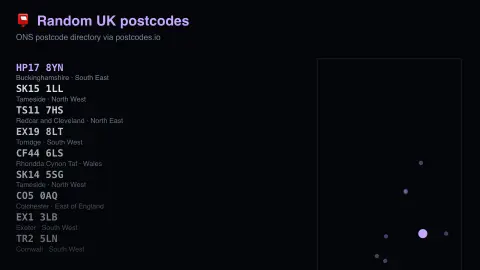
Press ESC to leave fullscreen. Settings are saved in your browser only.
How the Somewhere In Britain screensaver works
The saver reads postcodes.io, which serves the ONS postcode directory free of charge.
No account and no key: the request goes straight from your browser, or from this site's own refreshed copy of the feed where the source does not allow browser access.
Values are drawn on a canvas that resizes with the window, so it works on a laptop or a wall display.
If the source is unreachable the saver says so on screen rather than showing stale numbers as though they were current.
How a UK postcode points to a place
A British postcode has two parts separated by a space. The first, the outward code, is the postcode area (usually one or two letters) plus the district (one or two digits, or a digit and a letter in some London areas). The second, the inward code, is always three characters: a sector digit and a two-letter unit. In LA1 1EX, for example, the area is LA, the district 1, the sector 1 and the unit EX.
The modern system was devised by the General Post Office, now Royal Mail, to sort mail, and was adopted nationally in stages between 1959 and 1974. A full postcode typically identifies a group of roughly ten to fifteen addresses, or one large delivery point. Royal Mail is the statutory owner of the Postcode Address File, the master list of addresses and their postcodes.
Postcodes are a delivery tool, not a geographic one. The Office for National Statistics publishes a free postcode directory that links current and terminated postcodes to coordinates and to administrative and statistical areas, such as local authority and region. postcodes.io makes that kind of open data easy to query, which is how a random postcode becomes a spot on a map with its district name.
A worked example
New postcodes arrive every few seconds at the top of the list and fade as they are pushed down, while a rough outline of Britain on the right plots each one, the newest brightest. Because the sample is fair rather than curated, the result is mostly not the places that get talked about — it is Somerset villages and Midlands suburbs, because that is where the addresses are.
Settings & tips
- Accent and Background recolour the display without changing the data.
- Add it to a Multi-view grid to watch it alongside other live savers.
- Press ESC at any time to leave fullscreen.
Frequently asked questions
- How many UK postcodes are there?
- Roughly 1.7 million live postcodes, each covering an average of about fifteen addresses. The ONS directory maps every one to coordinates and to the administrative areas containing it.
- Is the map accurate?
- It is a rough projection of latitude and longitude onto a rectangle, good enough to show roughly where in Britain each postcode falls. It is a sketch for orientation, not a survey map.
- Is this real data?
- Yes. It comes from postcodes.io, which serves the ONS postcode directory free of charge. Nothing is invented or simulated, and if the source cannot be reached the saver reports that instead of drawing something plausible.
- Does it cost anything or need an account?
- No. Every screensaver here is free, runs in the browser and needs no sign-up. This one uses a public API that requires no key.
- Why do rural postcodes cover bigger areas?
- A postcode groups a small number of delivery points, so where addresses are sparse the area around them is much larger than in a dense city street.
- Is a postcode the same as an address?
- No. It identifies a small group of addresses, typically around ten to fifteen, so you usually still need a house number or name to pin down one building.
- Who owns postcode data?
- Royal Mail is the statutory owner of the Postcode Address File. The ONS separately publishes a free directory linking postcodes to statistical and administrative areas.