Flight Radar Screensaver
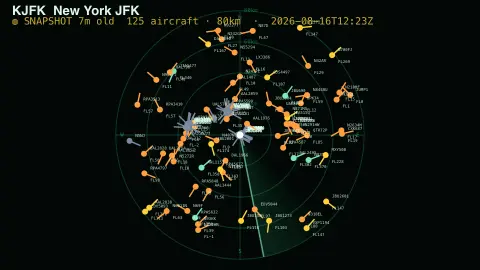
The Flight Radar screensaver shows live aircraft around a major airport on a sweeping radar scope, each blip labelled with its callsign and altitude. Positions come from the free OpenSky Network and glide smoothly between updates. It's free, runs in your browser, and ESC exits.
Live preview
Press ESC to leave fullscreen. Settings are saved in your browser only.
How the Flight Radar screensaver works
A small background job fetches a live snapshot of aircraft positions from the OpenSky Network and saves the planes near each airport to a data file. (OpenSky only lets its own site read the API directly, so the data is fetched server-side and served as a plain file.)
The saver draws a radar scope centred on your chosen airport: concentric range rings labelled in kilometres, compass bearings, and a green sweep line that rotates like a real radar, leaving a fading trail.
Each aircraft's latitude and longitude is converted into a position on the scope relative to the airport. Between refreshes the saver dead-reckons every plane — advancing it along its heading at its known speed each frame — so the blips move continuously instead of jumping.
Blips are coloured by altitude, draw a short line in their direction of travel, and are tagged with the callsign and flight level (FLxxx). A header shows the airport and how many aircraft are in range.
Where aircraft positions come from: ADS-B and OpenSky
Most commercial aircraft broadcast their identity, position, altitude and speed using ADS-B, short for Automatic Dependent Surveillance-Broadcast. On the common 1090 MHz link it works as a modified Mode S transponder, position is sent about once a second, and the content is not encrypted, so anyone with a suitable receiver can read it. Each aircraft carries a unique 24-bit ICAO transponder address.
The OpenSky Network began in 2012 as a research project and is now run by a non-profit association based in Switzerland. Its receivers, mostly in Europe and the US, are connected by volunteers, industrial supporters and academic and governmental organisations, and it offers several APIs. Data is free for academic and governmental research, with commercial licences available.
The data has natural gaps. Coverage depends on receivers being in range, so low-altitude aircraft and remote areas can be missed. Some owners can ask tracking services to block their aircraft, or use a temporary ICAO address, so not every flight is identifiable. A radar-style display shows a snapshot taken moments earlier, so treat it as a pleasant way to see how busy an airspace is, not as a navigation or tracking tool.
A worked example
Pick London Heathrow with an 80 km range and you'll usually see dozens of aircraft — a steady stream lined up on final approach from the east or west, departures climbing away, and high-altitude traffic crossing overhead in green. Drop the range to 40 km to zoom into the approach; raise it to 160 km to catch aircraft still inbound.
Settings & tips
- Airport picks which field to watch — eight major hubs are built in.
- Range sets the scope radius in kilometres; smaller zooms into approaches, larger catches distant traffic.
- Turn callsigns off for a cleaner scope, or tune the sweep speed to taste.
Frequently asked questions
- Is the flight data real?
- Yes. Aircraft positions come from the OpenSky Network, a community-run flight-tracking project, refreshed on a schedule. Coverage depends on OpenSky's receivers, so some flights may be missing.
- Why do the planes move smoothly between updates?
- The data refreshes about once a minute, but the saver advances each plane along its heading at its known speed every frame, so the blips glide instead of jumping.
- Which airports can I choose?
- Eight major hubs are built in, including New York JFK, London Heathrow, Frankfurt, Dubai and Tokyo Haneda. Pick one in the settings.
- Does it need internet?
- Yes, it reads a live data file that needs a connection. Offline, it shows a short notice instead of the scope.
- Is this flight radar screensaver free?
- Yes, free and browser-based with no key or download. Run it fullscreen and press ESC to exit.
- Why are some aircraft missing?
- The network only sees aircraft within range of its receivers, and privacy programs let some owners block or mask their aircraft, so some flights do not appear or cannot be identified.
- Is the ADS-B signal secret or encrypted?
- No. ADS-B content is not encrypted, so it can be read by anybody with a suitable receiver. That openness is what lets a volunteer network collect it.
- Is this safe to use for planning travel?
- No. Positions are delayed snapshots from an open data feed, so use official airline and airport information for any travel decision.