Navigation Warnings Screensaver
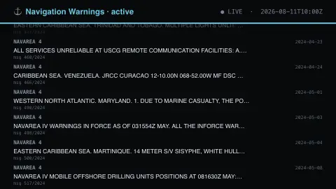
The Navigation Warnings screensaver shows real active NGA broadcast warnings to mariners — wrecks, drifting hazards, live-fire exercises, unlit buoys and GPS interference, by sea area. Informational only, and no substitute for the official Notice to Mariners. It's free, runs in your browser, and ESC exits.
Live preview
Press ESC to leave fullscreen. Settings are saved in your browser only.
How the Navigation Warnings screensaver works
The background pipeline reads this from NGA Maritime Safety and saves a snapshot the saver loads.
Real active NGA broadcast warnings to mariners — wrecks, drifting hazards, live-fire exercises, unlit buoys and GPS interference, by sea area.
It refreshes on a schedule, so what you see stays current.
Colours can be changed in settings; nothing is stored beyond your own browser.
How broadcast warnings to mariners work
Ships rely on navigational warnings to learn about dangers that charts cannot show: a drifting container, a wreck, a buoy that is not lit or a naval live-fire exercise. The world’s oceans are divided into 21 NAVAREAs (16 set up in the 1970s and five Arctic areas added in 2007). Each has one Area Coordinator, a designated national body, and IMO Assembly Resolution A.706(17) covers this system. The US National Geospatial-Intelligence Agency acts as coordinator for NAVAREAs IV and XII and publishes warnings through its Maritime Safety Information service.
Warnings are sent by methods such as NAVTEX and Inmarsat-C, generally in English, so they are written tersely. Each warning has an identifying number, an area and a block of text. Once a warning is no longer relevant it is cancelled, and a longer-term hazard is normally moved into a notice to mariners instead, so the list mixes brand-new notices with ones that have been in force for some time.
This is a view of text published for professionals, not a navigation aid. Warnings are updated and cancelled constantly, and the display cannot replace the official notices and broadcasts that mariners are required to use.
A worked example
Real active NGA broadcast warnings to mariners — wrecks, drifting hazards, live-fire exercises, unlit buoys and GPS interference, by sea area. Informational only, and no substitute for the official Notice to Mariners.
Settings & tips
- Accent and Background recolour the display.
- Run
automation/run.py navwarningsto refresh the feed. - Press ESC to leave fullscreen.
Frequently asked questions
- Is this real data?
- Yes — it comes from NGA Maritime Safety and is refreshed on a schedule.
- Can I navigate using this?
- No. It is informational only and is not a substitute for the official Notice to Mariners or any other authoritative navigation source.
- Is a key needed?
- No. This source is fully key-less.
- Is it free?
- Yes — free, no download, in your browser.
- Who issues these warnings?
- Each NAVAREA has a designated coordinator. The US National Geospatial-Intelligence Agency coordinates NAVAREAs IV and XII, and its Maritime Safety Information service publishes the warnings shown here.
- Why are the messages written in capital letters with odd abbreviations?
- Warnings are sent by systems such as NAVTEX and Inmarsat-C, so they are written in a terse, standardised style rather than ordinary prose.
- Why do old-looking warnings still appear?
- A warning stays in force until it is cancelled. Longer-term hazards are normally moved into a notice to mariners, so some warnings can remain active for a while before that happens.