Live Ocean Float Positions Screensaver
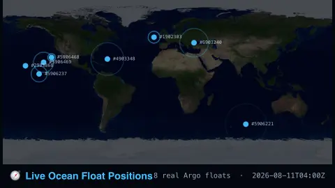
The Live Ocean Float Positions screensaver maps real Argo ocean float positions worldwide. It is free, runs in your browser, and ESC exits.
Live preview
Press ESC to leave fullscreen. Settings are saved in your browser only.
How the Live Ocean Float Positions screensaver works
The saver reads real current positions for a set of Argo floats from the Argovis API.
Each marker is a real autonomous float at its real last-reported location.
The pipeline refreshes positions regularly as floats surface and report.
No key is required for light polling of this public endpoint.
How an Argo float spends its life
Argo is an international programme in which robotic floats drift through the open ocean. It began in 2000, and about 30 countries operate floats, each funding its own floats and data processing. A float changes its buoyancy with a hydraulic pump that moves oil between an internal reservoir and an external bladder, letting it sink and rise without a propeller. It has no steering, so it travels with the currents.
A standard cycle lasts 10 days. The float drifts at a parking depth of about 1,000 metres for roughly nine days, sinks to 2,000 metres, then rises slowly to the surface measuring conductivity, temperature and pressure on the way. At the surface it transmits its data and position by satellite before sinking again. Some floats carry additional sensors for biological and chemical properties of the ocean.
Argovis is a service that makes this data searchable. Because a float is located only when it surfaces, the marker on the map is the position of its latest report, and the float may have drifted some distance since. Floats usually last four to five years until they stop working, so the fleet is constantly replenished and the map reflects the ones currently reporting.
A worked example
A real float that surfaced days ago appears on the map at its real drifted position, exactly as reported to Argovis.
Settings & tips
- Floats are real autonomous ocean sensors, part of the global Argo program.
- Accent recolours the float markers.
- Floats surface roughly every 10 real days to transmit their profile.
Frequently asked questions
- Is this real ocean data?
- Yes — real Argo float positions from the Argovis API.
- Is a key needed?
- No, not for light polling — a free key raises the rate limit.
- What do the floats measure?
- Real ocean temperature and salinity profiles as they drift and dive.
- Is it free?
- Yes — free, no download, in your browser.
- How do Argo floats move?
- They do not steer. They change their density with an oil-filled bladder to sink or rise and are carried horizontally by ocean currents while submerged.
- Why does a marker not move between refreshes?
- A float surfaces to report only about once every 10 days, so its position is the place of the last surfacing, not a live track.
- How long does a float last?
- Usually four to five years, after which it stops reporting and is replaced by newer ones.