Global Disaster Alert Board Screensaver
The Global Disaster Alert Board screensaver maps real active multi-hazard disaster alerts worldwide. It is free, runs in your browser, and ESC exits.
Live preview
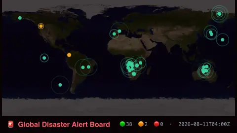
Press ESC to leave fullscreen. Settings are saved in your browser only.
How the Global Disaster Alert Board screensaver works
The saver reads real active alerts from GDACS's own public RSS feed.
Each marker shows a real hazard type, alert level and location.
The pipeline refreshes the feed regularly as GDACS updates its alerts.
No key is required for this key-less public endpoint.
How GDACS grades disasters
The Global Disaster Alert and Coordination System, GDACS, is a cooperation framework between the United Nations and the European Commission. Its secretariat sits within the UN Office for the Coordination of Humanitarian Affairs in Geneva, and the European Commission’s Joint Research Centre provides the automatic estimates and risk analysis behind its notifications. It covers major sudden-onset disasters such as earthquakes, tropical cyclones, floods, volcanoes, droughts and forest fires, so that responders can quickly gauge whether international help may be needed.
The alert level is a colour, set by hazard-specific models. Green marks events where international help is not likely to be needed, orange potential local disasters where international assistance might be required, and red potentially severe disasters where it is expected to be required. The level is not the physical strength of an event: the earthquake model, for example, weighs population exposure and vulnerability as well as magnitude, so a large quake far from people can rate lower than a smaller one near a city.
Because alerts are produced quickly, initial numbers can be revised as better data arrive, and a level can be raised or lowered. The scores estimate potential impact and are not confirmed casualty figures. This display is a global overview and is not an emergency warning service, so follow local authorities in any real situation.
A worked example
A real green-level earthquake alert appears on the map at its real reported location, exactly as GDACS scored it.
Settings & tips
- Alert levels (green/orange/red) are GDACS's own real automated severity scoring.
- Accent recolours the alert markers.
- Hazard types span real earthquakes, floods, cyclones, volcanoes and droughts.
Frequently asked questions
- Is this real disaster data?
- Yes — real active alerts from GDACS's own public feed.
- Is a key needed?
- No. GDACS's RSS feed is fully key-less.
- Should I use this for emergency decisions?
- No — it's a display-only screensaver, not an official warning system.
- Is it free?
- Yes — free, no download, in your browser.
- What do green, orange and red mean?
- They are GDACS alert levels for expected humanitarian impact. Green means international help is not likely to be needed, orange means it might be, and red means it is expected to be. They are not a measure of an event's physical size.
- Why can an alert level change?
- Alerts are issued quickly from automated estimates, and they can be updated as better measurements and impact estimates come in.
- Who runs GDACS?
- It is a cooperation framework between the United Nations and the European Commission, with its secretariat in the UN Office for the Coordination of Humanitarian Affairs and automatic estimates from the Joint Research Centre.