The Largest Cities On Earth Screensaver
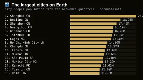
The Largest Cities On Earth screensaver ranks the world's largest cities by population from the GeoNames gazetteer, which holds every settlement over a thousand people — about 170,000 of them. The answer is not the one most people expect. It runs in the browser with nothing to install; press ESC to exit.
Live preview
Press ESC to leave fullscreen. Settings are saved in your browser only.
How the The Largest Cities On Earth screensaver works
The saver reads The GeoNames gazetteer, served through the Opendatasoft public catalogue.
No account and no key: the request goes straight from your browser, or from this site's own refreshed copy of the feed where the source does not allow browser access.
Values are drawn on a canvas that resizes with the window, so it works on a laptop or a wall display.
If the source is unreachable the saver says so on screen rather than showing stale numbers as though they were current.
Counting cities: city proper versus urban area
There is no single answer to which city is the largest, because it depends on where you draw the boundary. A city proper is the area inside its official administrative limits. An urban agglomeration is the continuous built-up area around it, and a metropolitan area also includes commuter towns linked by daily travel. The same place can have very different populations under each definition, and rankings change accordingly.
This saver draws on GeoNames, a geographical database of place names and features that is free to download and can also be edited by users through a wiki interface. It integrates data from many sources, including the US National Geospatial-Intelligence Agency, the US Geological Survey, Ordnance Survey and Canadian geographical names, and it lists millions of populated places. Population values come from varied sources, so their dates and methods are not uniform and are not strictly comparable between countries.
The consequence is that the order of a list like this depends on what the gazetteer holds for each place and on how that place's limits are drawn. A tightly bounded city may rank below one with a huge administrative area. Populations also age quickly, especially where growth is rapid. Treat the ranking as a rough picture of scale, not an official league table.
A worked example
Sixteen cities ranked by population with their country code alongside. The top is overwhelmingly Chinese and Indian, and several entries most Europeans could not place on a map outrank every city in Europe. These are city-proper figures from national censuses of varying vintage, not metropolitan areas, which is why Tokyo appears smaller than its famous 37-million metro figure.
Settings & tips
- Accent and Background recolour the display without changing the data.
- Add it to a Multi-view grid to watch it alongside other live savers.
- Press ESC at any time to leave fullscreen.
Frequently asked questions
- Why is Tokyo not first?
- Because these are city-proper populations — the administrative city — rather than metropolitan areas. Tokyo's 37 million figure counts a vast surrounding region; the city itself is considerably smaller.
- How current are the figures?
- They come from national censuses collected at different times, so the vintage varies by country. GeoNames is a gazetteer rather than a live population counter.
- Is this real data?
- Yes. It comes from The GeoNames gazetteer, served through the Opendatasoft public catalogue. Nothing is invented or simulated, and if the source cannot be reached the saver reports that instead of drawing something plausible.
- Does it cost anything or need an account?
- No. Every screensaver here is free, runs in the browser and needs no sign-up. This one uses a public API that requires no key.
- What is the difference between a city and a metropolitan area?
- A city proper is the area within its administrative limits, while a metropolitan area also includes surrounding communities linked to it, such as commuter towns. Metropolitan figures are generally larger.
- Where do GeoNames populations come from?
- GeoNames integrates population data from various sources, and its data also comes from national agencies and user edits, so dates and methods can differ by place.
- Why can city rankings differ between websites?
- Sources use different boundary definitions, reference years and estimation methods, so the same city can have quite different totals.