Ships In The Baltic Screensaver
The Ships In The Baltic screensaver shows live AIS positions from Fintraffic's coastal receiver network, read key-less. It's free, runs in your browser, and ESC exits.
Live preview
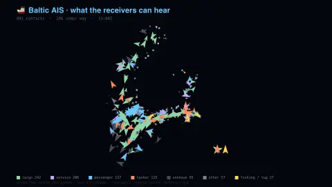
Press ESC to leave fullscreen. Settings are saved in your browser only.
How the Ships In The Baltic screensaver works
The saver reads the source described above and draws it on a canvas — no account, no tracking.
Live AIS positions from Fintraffic's coastal receiver network, read key-less. Every commercial vessel broadcasts position and heading in the clear; this is the Gulf of Finland and the northern Baltic, not the world, and names come from a separate registry.
It refreshes on a schedule, so what you see stays current.
Colours and any options can be changed in settings; nothing is stored beyond your own browser.
What an AIS receiver can and cannot hear
AIS, the Automatic Identification System, is a VHF radio broadcast in which a vessel announces its identity, position, course and speed. A Class A transponder reports every 2 to 10 seconds while underway, depending on speed, and every 3 minutes at anchor. Under the IMO’s SOLAS convention AIS is required on ships of 300 gross tonnage or more on international voyages and on all passenger ships, and many smaller boats carry a Class B unit voluntarily. Each vessel is identified by a nine-digit MMSI number.
The positions here come from Fintraffic’s Digitraffic open-data service, which publishes marine traffic data collected by Fintraffic, the Finnish Transport Infrastructure Agency and Traficom, based on AIS messages that vessels broadcast. Because VHF is limited by line of sight, land-based AIS reception drops away beyond coastal waters, with a maximum reach of roughly 74 km.
What you see is therefore a sample of the sea, not all of it. Vessels without a transponder and anything beyond receiver range are invisible, ships can switch their transceivers off, and AIS relies on the cooperation of the people using it, so a vessel can broadcast falsified position or identity data. Treat each dot as what was broadcast, not independent confirmation of where a ship is.
A worked example
Live AIS positions from Fintraffic's coastal receiver network, read key-less. Every commercial vessel broadcasts position and heading in the clear; this is the Gulf of Finland and the northern Baltic, not the world, and names come from a separate registry.
Settings & tips
- Accent and Background recolour the display.
- Every value on screen comes from the live source — nothing is simulated.
- Press ESC to leave fullscreen.
Frequently asked questions
- Is this real data?
- Yes — it comes from the source named on this page and is refreshed on a schedule.
- Is a key needed?
- No. This source is fully key-less.
- Is it free?
- Yes, and it runs entirely in your browser.
- Why do some ships appear to jump or vanish?
- A vessel drops out when it leaves receiver range or its transponder stops broadcasting, and reappears when it is heard again.
- Does every ship in the Baltic show up?
- No. Only vessels that transmit AIS within range of the receivers are shown, so small craft without AIS, ships that have switched it off and anything out of range are absent.