New Zealand Earthquakes Screensaver
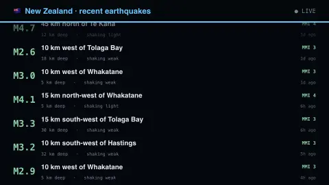
The New Zealand Earthquakes screensaver shows recent New Zealand earthquakes from GeoNet, key-less. It's free, runs in your browser, and ESC exits.
Live preview
Press ESC to leave fullscreen. Settings are saved in your browser only.
How the New Zealand Earthquakes screensaver works
The saver reads the source described above and draws it on a canvas — no account, no tracking.
Recent New Zealand earthquakes from GeoNet, key-less. GeoNet reports shaking intensity (MMI) alongside magnitude, which describes how hard the ground actually moved where people are rather than how much energy the rupture released.
It refreshes on a schedule, so what you see stays current.
Colours and any options can be changed in settings; nothing is stored beyond your own browser.
Reading shaking intensity in New Zealand
GeoNet is New Zealand's geological hazard monitoring programme, a partnership between Natural Hazards Commission Toka Tu Ake, Earth Sciences NZ and Land Information New Zealand. Its stated aim is to detect, analyse and respond to earthquakes, volcanic activity, large landslides and tsunami. New Zealand lies across the boundary of the Pacific and Australian plates, which is why earthquakes are frequent.
Magnitude and intensity are different questions. Magnitude measures the size of the earthquake at its source, a single number per event. Intensity describes the shaking and its effects at a given place. GeoNet uses the New Zealand version of the Modified Mercalli scale, which on its page runs from MM 1, felt by almost no one, to MM 11, where most of the second-weakest building types are destroyed. Levels around MM 5 are felt by nearly everyone indoors, and MM 6 begins to cause slight damage to weaker buildings.
Because intensity is about local effects, the same earthquake produces different levels in different places, and ground conditions such as soft soils change the shaking. Locations are given relative to a named place, such as a distance and direction from a town. Values from automatic processing may be revised once analysts review the data.
A worked example
Recent New Zealand earthquakes from GeoNet, key-less. GeoNet reports shaking intensity (MMI) alongside magnitude, which describes how hard the ground actually moved where people are rather than how much energy the rupture released.
Settings & tips
- Accent and Background recolour the display.
- Every number on screen comes from the live source — nothing is simulated.
- Press ESC to leave fullscreen.
Frequently asked questions
- Is this real data?
- Yes — it comes from the source named on this page and is refreshed on a schedule.
- Is a key needed?
- No. This source is fully key-less.
- Is it free?
- Yes — free, no download, in your browser.
- What is the Modified Mercalli scale?
- A scale describing the effects of shaking at a location, from barely felt to severe building damage, based on what people and structures experience. GeoNet uses the New Zealand version, MM 1 to MM 11.
- Why can a bigger earthquake feel weaker than a smaller one?
- Magnitude is the size at the source, while intensity is the effect at your location. Distance, depth and local ground conditions all change how strongly a place shakes.
- Do values on screen change later?
- They can. Early solutions may be revised, so magnitude, depth or location may be adjusted after review.