Global Flood Forecast Screensaver
The Global Flood Forecast screensaver shows forecast river discharge for major world rivers over the next 30 days, from Open-Meteo's key-less flood API serving the Copernicus GloFAS model. A model forecast, not a flood warning. It's free, runs in your browser, and ESC exits.
Live preview
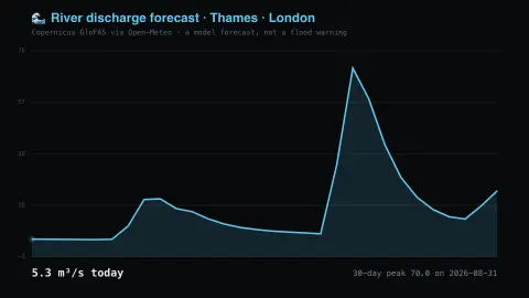
Press ESC to leave fullscreen. Settings are saved in your browser only.
How the Global Flood Forecast screensaver works
The saver reads Open-Meteo's flood API directly in your browser — no key and no account.
Forecast river discharge for major world rivers over the next 30 days, from Open-Meteo's key-less flood API serving the Copernicus GloFAS model.
It refreshes on a schedule, so what you see stays current.
Colours can be changed in settings; nothing is stored beyond your own browser.
What the GloFAS model estimates
The Global Flood Awareness System, GloFAS, is one component of the Copernicus Emergency Management Service, implemented by the European Commission. Its forecasts are driven by ensemble weather forecasts from the ECMWF Integrated Forecast System, which feed the open-source LISFLOOD hydrological model, a spatially distributed, physically based model of how water moves through river basins.
Since version 4.0 became operational in July 2023, GloFAS has run on a grid of 0.05 degrees, about 5 km, compared with about 10 km for earlier versions. Open-Meteo’s flood API returns daily river discharge in cubic metres per second for the largest river in a roughly 5 km area around the requested coordinates, so a point beside a small stream may report the flow of a larger river nearby.
Discharge is the volume of water passing a location each second, which is a different quantity from river level, a height. The same discharge can mean different water levels depending on the shape of the channel, and a figure has to be read against that river’s own normal range. GloFAS is aimed at preparing for floods in large river basins, so small catchments and flash floods are poorly represented, and forecast uncertainty grows with lead time. Operational warnings come from national flood authorities.
A worked example
Forecast river discharge for major world rivers over the next 30 days, from Open-Meteo's key-less flood API serving the Copernicus GloFAS model. A model forecast, not a flood warning.
Settings & tips
- Accent and Background recolour the display.
- Data comes straight from Open-Meteo's flood API in your browser.
- Press ESC to leave fullscreen.
Frequently asked questions
- Is this real data?
- Yes — it comes from Open-Meteo's flood API and is refreshed on a schedule.
- Is this a flood warning?
- No. It is a model forecast of how much water is expected to be flowing in a river reach. It is not a warning and no authority issues it.
- Is a key needed?
- No. This source is fully key-less.
- Is it free?
- Yes — free, no download, in your browser.
- What is river discharge?
- It is the volume of water flowing past a point per second, typically in cubic metres per second, rather than the height of the water.
- Why is a thirty-day forecast less certain at the end?
- The forecasts start from weather predictions, which lose skill with lead time, and river flow depends on rainfall, so later days carry more uncertainty.
- Does this cover small streams?
- Not well. The model works on a grid of about 5 km and is aimed at larger river basins, so small catchments and flash floods are poorly represented.